
After a Hurricane, Which Property Evidence Can Still Be Trusted?
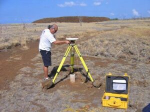
A major storm rearranges a property without touching the deed. Land surveying after that kind of event separates what moved from what still holds legal weight, and the two rarely match. Fences lie in the street. Corner markers sit under three feet of sand or debris. Owners look at the ground and cannot tell where anything belongs, and rebuilding cannot start until somebody answers that question with evidence.
Inspecting Monuments After Debris Removal and Ground Disturbance
Property corners take a beating during a storm and during the cleanup that follows. Wind and water can move an iron pin, though heavy equipment does far more damage. Loaders scraping debris off a lot will pull a marker out of the ground without anyone noticing, and the marker gets hauled away with the wreckage.
Crews check each monument they recover against the record before trusting it. A pin that sits three feet from where the math puts it has moved, and using it would spread that error across the whole survey. Recovering enough good evidence to prove the questionable ones is the real work of a post-storm boundary survey.
Separating Temporary Storm Changes From Recorded Ownership
Property lines live in documents, and storms do not amend documents. A fence pushed twenty feet sideways still marks nothing more than where a fence used to stand. Sand piled into a new dune, a shoreline cut back by surge, a driveway now pointing somewhere it never pointed before, none of that redefines a boundary.
Owners find this hard to accept, and understandably so. The ground in front of them looks like a different property. The survey holds the record line steady while showing the new physical conditions beside it, so the owner can see exactly how far the visible world has drifted from the legal one.
Rebuilding the Boundary From Records and Surviving Evidence
Reconstruction starts in the record. The surveyor pulls the deed, the subdivision plat, earlier surveys and any control that exists nearby, then goes looking for whatever survived. Evidence worth searching for after a storm includes:
- original monuments still in place, even if buried under sand or debris
- monuments on neighboring lots that the storm treated more kindly
- published control points and benchmarks in the surrounding area
- foundations, seawalls and other heavy features that did not move
- older survey drawings showing ties from corners to nearby objects
One solid monument can anchor an entire block. Crews follow that evidence outward, rebuilding the line from what remains rather than starting over with fresh measurements that answer to nothing.
Locating the Remaining Improvements Before Reconstruction
Rebuilding needs a picture of what is left. The survey locates surviving foundations, slabs, piles, seawalls, utility connections, driveways and steps, then places them against the resolved boundary. Some of those improvements will get reused, and some will not.
That drawing answers questions the design team cannot answer from photographs. A slab that sat within the setback before the storm still sits within it. A seawall that shifted may now cross a line it never crossed. Knowing which improvements can serve the new plan shapes the design and the budget from the first meeting.
Creating a Reliable Base for Permits and Rebuilding Decisions
Permit offices after a storm face a flood of applications and very little patience for guesswork. A current survey showing the resolved boundary, the surviving improvements and the existing grades gives a reviewer something solid to work with. It also gives the owner a defensible record of conditions at a specific date.
That record matters beyond the permit. Insurance claims, contractor disputes and neighbor disagreements all trace back to what stood where and when. A survey completed early in the recovery becomes the document everyone else builds on, and it usually saves more time than it costs.
Frequently Asked Questions
Does a storm change my property line?
No. The recorded boundary stays where the documents put it, and physical damage does not amend those documents. What changes is the evidence on the ground, which makes finding the line harder without changing where it sits.
My corner markers are gone. Can they be replaced?
Yes. A surveyor rebuilds missing corners from the record and from surviving evidence, including monuments on nearby lots and established control. The replacement corner goes back in the position the record supports rather than in a spot chosen for convenience.
Should I get a survey before or after debris removal?
Before, when the schedule allows it. Cleanup equipment destroys more monuments than the storm itself, so recording what survives ahead of that work preserves evidence that would otherwise disappear. When cleanup has already happened, the survey still works, and it simply takes more searching.
For a free land surveying quote, call us at (571) 200-5708 or send us a message by going here.
Posted in land surveying, land surveyor
