
A Boundary Survey Could Save You From a Very Costly Mistake
Have you ever wondered exactly where your property ends and your neighbor’s begins? A boundary survey gives you the answer. It is one of the most common land surveys in the United States, and for good reason. Property lines are not always where people think they are. Finding out after the fact can lead to serious and expensive problems.
What Is a Boundary Survey?
A boundary survey is a professional measurement of a property. A licensed land surveyor looks through public records, deeds, and old documents, then visits the property to find and mark each corner. The final result is a certified map that shows the legal edges of your land.
A boundary survey is all about legal ownership lines. It answers one simple but important question: where exactly does your property begin and end?
Property line disagreements are very common. They happen because of unclear deeds, old surveys that are no longer accurate, or structures like fences that were built in the wrong place. A boundary survey is the clearest and most legally accepted way to sort things out.
How Does a Boundary Survey Work?
The process has four main steps. Here is what happens from start to finish.
Step 1: Research The surveyor looks up public records, either at the courthouse or online. They collect deeds for your property and all the properties next to it, along with any old surveys, easement records, and maps. This research is the foundation for everything that comes next.
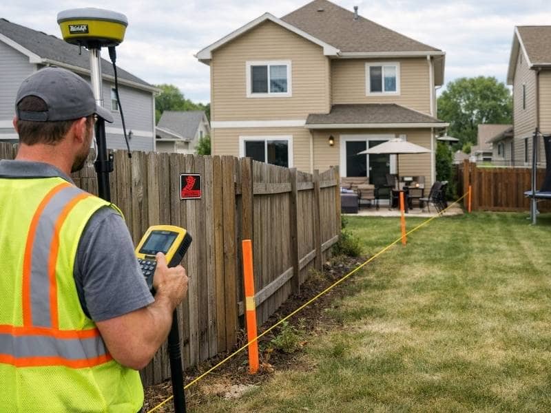
Step 2: Fieldwork A survey crew visits your property and looks for existing boundary markers. These are usually iron rods, concrete pins, or stones. They also look at nearby features like fences, driveways, and buildings that might be close to or crossing the property line. They use tools like GPS receivers and total stations to take accurate measurements.
Step 3: Analysis The surveyor compares what was found on the ground with what the records say. If the two do not match, the surveyor uses their training and the law to figure out where the real boundary is.
Step 4: Final Map and Report The surveyor creates a certified boundary map that shows all corners, lines, and measurements. It also notes any easements or encroachments. This document is legally valid and can be used for permits, property sales, and even in court.
Most residential boundary surveys take one to three weeks from start to finish.
When Do You Need a Boundary Survey?
There are several situations where a boundary survey is not just helpful but important.
Before buying property. A boundary survey confirms that the land you are buying matches what the deed says. Surveyors often find problems during real estate deals, including structures from neighboring properties that cross the line and easements that limit what you can do with the land.
Before building a fence, shed, deck, or addition. Building even a few inches past your property line can cause a legal fight with your neighbor. A boundary survey shows you exactly where you can build before you start, saving you from having to move or tear down a structure later.
When a neighbor disputes your property line. These disagreements are very common. They usually start small, like a fence in the wrong spot, but can get serious fast. A boundary survey gives both sides a clear, unbiased, and legally accepted answer.
When clearing or developing land. Before you clear trees, grade the land, or start any development, knowing your exact boundaries keeps you from accidentally crossing onto someone else’s property.
When an old survey exists but might be outdated. Surveys from many years ago may not show changes to easements, new rules, or physical changes to the land. A new boundary survey gives you accurate and current information.
What Can a Boundary Survey Reveal?
A boundary survey does more than just mark corners. It can uncover problems that are not easy to see on your own.
- Encroachments. A neighbor’s fence, driveway, or shed might be sitting on your land without anyone realizing it. If left alone long enough, this can sometimes lead to legal claims over that piece of land.
- Easements. An easement gives someone else the legal right to use part of your property. A utility company running a power line across your yard is one example. A boundary survey will document any easements on your land.
- Gaps and overlaps. Old deeds sometimes have descriptions that leave spaces between properties or cause two properties to overlap. These issues need to be fixed before you can sell or develop the land.
- Setback violations. If a structure on your property is too close to the boundary line, it may break local zoning rules. A boundary survey catches this early, before it causes problems with permits or a future sale.
How Much Does a Boundary Survey Cost?
The cost depends on the size of the property, the terrain, and how much research is needed. According to HomeGuide (2026), a boundary survey for a property up to half an acre usually costs between $300 and $900. Larger or more complicated properties cost more.
The survey almost always costs far less than a legal dispute, a forced demolition, or a deal that falls through. It is a small investment that protects a much bigger one.
Frequently Asked Questions
Is a boundary survey legally binding?
Yes. A survey done by a licensed land surveyor produces a certified legal document. You can use it for permit applications, real estate transactions, and as evidence in court.
Does a property deed replace a boundary survey?
No. A deed describes your property in writing, but it does not physically show where the boundaries are on the ground. A boundary survey takes that written description and turns it into real, marked locations you can see and use.
How is a boundary survey different from a property appraisal?
A property appraisal tells you what your property is worth in dollars. A boundary survey tells you where your property legally begins and ends. They serve two completely different purposes and cannot replace each other.
Can I use an old survey from when I bought my home?
You can use it as a starting point, but older surveys may not reflect current easements, regulations, or changes to the land. If you are planning to build, sell, or resolve a dispute, a current survey is always the safer choice.